
Auckland to Cape Reinga campervan route
The drive from Auckland to Cape Reinga takes you to the very top of New Zealand — through the islands and history of the Bay of Islands, up the long Aupōuri Peninsula, to the lighthouse at the tip where the Tasman Sea and the Pacific collide. It's a gentler, warmer trip than the South Island routes — the "winterless north" — and a brilliant first road trip in a campervan, motorhome or caravan. Here's how to plan it, the best stops and camps, and the one Far North warning every renter needs to hear.
- Distance
- ~670 km Auckland → Cape Reinga (one way); ~265 km to the Bay of Islands
- Driving time
- ~8 hours each way; plan a 5–7 day loop, not a day trip
- Suggested days
- 5–7 days return, via the east coast up and west coast back
- Main route
- SH1 via Whangārei, Bay of Islands, Kaitaia to Cape Reinga; return via Hokianga & Waipoua
- Best time
- Year-round — the "winterless north" is mild even in winter
The short version
- It's a loop, not a dash — east coast up (Bay of Islands), west coast back (Waipoua kauri forest).
- Base a night or two in the Bay of Islands — it's the heart of the trip.
- Do NOT drive your campervan on Ninety Mile Beach — it's prohibited by rental contracts and voids your insurance. Take a tour.
- The road to Cape Reinga is fully sealed — any rig can reach the tip; just fuel up in Kaitaia.
- The winterless north is a great cold-season trip when the South Island is under snow.
The drive, leg by leg
Auckland → Bay of Islands (~3 hours, ~265 km)
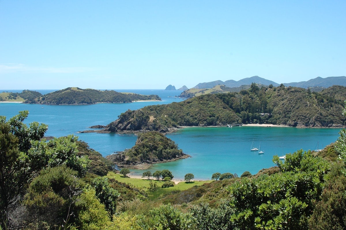
Head north out of Auckland on State Highway 1, over the harbour and up through the rolling Northland farmland. Whangārei — the region's largest town — is a good stop for supplies and the Whangārei Falls. Carry on to the Bay of Islands: the seaside village of Paihia is the gateway, historic Russell is a short ferry across the water, and the Waitangi Treaty Grounds — where the Treaty of Waitangi was signed in 1840 — are among the most significant historic sites in the country. It's worth a night or two: island cruises, the Hole in the Rock, and dolphins are all on the doorstep.
Bay of Islands → Cape Reinga (~3 hours, ~220 km)
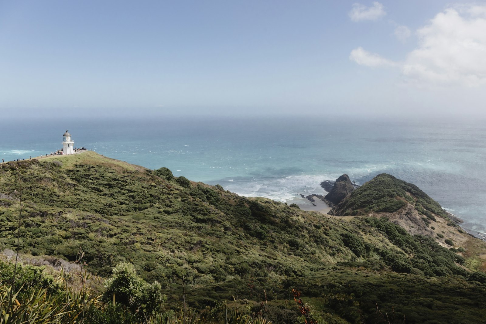
North of the Bay of Islands the country empties out. Mangōnui on Doubtless Bay is famous for its fish and chips, and Kaitaia is the last main town — fuel up here. From there it's the long, beautiful run up the Aupōuri Peninsula to Cape Reinga / Te Rerenga Wairua: the lighthouse, the swirling line where two oceans meet, and a place of deep spiritual significance in Māori culture as the departing point of spirits.
The west-coast return (Hokianga & the kauri forest)
Come back down the west coast for a completely different feel: the wide Hokianga Harbour with its giant dunes, and the Waipoua Forest, home to Tāne Mahuta — New Zealand's largest living kauri, and a genuinely humbling stop. This loop adds a couple of hours over backtracking, and it's well worth it.
The one Far North warning: Ninety Mile Beach
Where to stay: camps along the way
Northland is full of coastal campsites:
- Tapotupotu (DOC) — New Zealand's northernmost campsite, about 5 minutes from Cape Reinga; basic facilities, suits campervans, stunning bay.
- Spirits Bay / Kapowairua (DOC) — another remote site near the tip, for tents, campervans and caravans.
- Uretiti Beach (DOC) — near Whangārei, one of the most popular DOC campsites in the country; book ahead in summer.
- Bay of Islands — plenty of holiday parks around Paihia and Kerikeri for a serviced night near the action.
The winterless north
One of the best things about this route: Northland is subtropical and mild all year. While the South Island passes are dealing with snow and ice, the Far North stays green and warm enough to enjoy — so this is a brilliant winter or shoulder-season trip, when it's quieter and cheaper up here. Pack for sun and the odd subtropical downpour rather than for the cold.
Check the forecast before you go → The free Touring Brain weather briefing flags gusts at cab height and the rain outlook — handy for the exposed coast roads and the subtropical showers up north.Frequently asked questions
How long does the Auckland to Cape Reinga trip take?
About 8 hours of driving each way, so plan a 5–7 day loop, not a day trip — up the east coast through the Bay of Islands, and back down the west coast through the Waipoua kauri forest.
Can I take a caravan to Cape Reinga?
Yes — the road is sealed the whole way, so a caravan or large motorhome is fine. The Far North is remote, so fuel up in Kaitaia, and remember the beach is off-limits.
Is the Bay of Islands worth a stop?
Absolutely — it's the heart of the trip. Stay a night or two for Russell, the Waitangi Treaty Grounds and an island cruise. It's also a top New Zealand must-see.
Sources & further reading: roads, conditions and beach-driving rules — NZTA Waka Kotahi; Cape Reinga, Waipoua and campsites — Department of Conservation (Northland); weather — MetService. Distances and times are approximate and were last reviewed on 19 June 2026.
This guide is general touring information, not legal or driver-training advice, and conditions change quickly. Always follow road signs and NZTA Waka Kotahi guidance, never drive a rental on Ninety Mile Beach or other sand, confirm campsite availability, self-containment requirements and bylaws before you arrive, and drive to the conditions on the day. Touring Brain is independent and not affiliated with NZTA, DOC or any tour or rental operator.
Photos: Cape Reinga — Tobias Rademacher; Bay of Islands — Linde Lanjouw (Unsplash).