
Christchurch to the West Coast via Arthur's Pass
Crossing the Southern Alps from Christchurch to the West Coast over Arthur's Pass is one of New Zealand's great short drives — a couple of hundred kilometres that climb from the Canterbury Plains through limestone country and beech forest to an alpine pass, then drop down the dramatic Otira gorge to the wild West Coast. It's a normal sealed highway and campervans drive it every day, but it's a genuine alpine route, so a big rig has a few things to get right. Here's the drive, the stops, and the bits that matter.
- Distance
- ~240 km Christchurch → Greymouth via SH73
- Driving time
- ~3.5 hours non-stop; easily a half or full day with stops
- Highest point
- Arthur's Pass, 920 m
- Main stops
- Castle Hill, Arthur's Pass village, Otira Viaduct, Greymouth / Hokitika
- Best time
- Year-round; in winter carry chains and check road status
The short version
- It's a real alpine pass — to 920 m, with a steep western descent. Take it slowly in a big rig.
- Use a low gear going down the Otira — sections hit ~16% — so the engine brakes instead of overheating the foot brake.
- Carry chains in winter — most likely needed at the Otira Viaduct, Porters Pass and Craigieburn Cutting.
- No dump station or powered sites in the village — sort fuel, water and waste before the pass.
- Watch for kea — don't feed them; they'll happily strip rubber and trim off a parked vehicle.
The drive, stop by stop
Christchurch → Arthur's Pass village (~2 hours, ~150 km)
Out of Christchurch the road crosses the Canterbury Plains to Springfield (a good last-services stop), then climbs Porters Pass into the high country. Castle Hill — a field of giant limestone boulders — is a classic leg-stretch, before the road runs through Craigieburn and up the Waimakariri valley to Arthur's Pass village, the little alpine settlement at the top, where kea patrol the car parks.
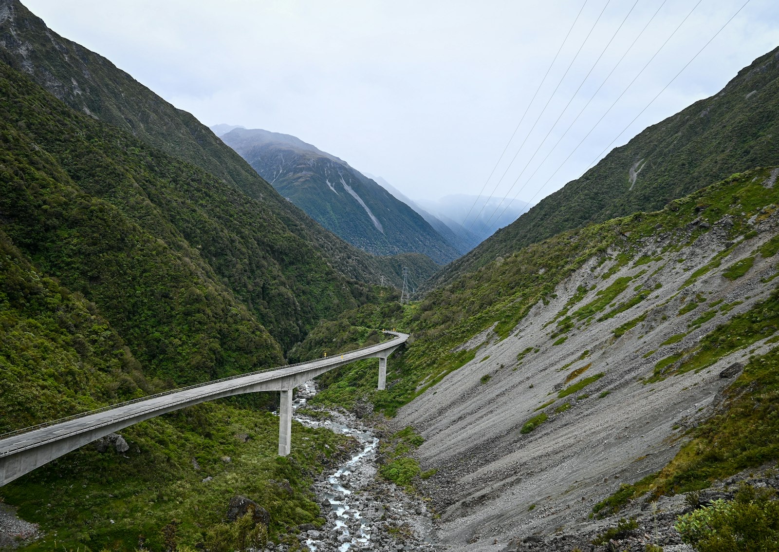
The Otira Viaduct & the descent to the coast (~1.5 hours, ~90 km)
West of the village the road drops sharply down the Otira gorge via the Otira Viaduct — an impressive curved bridge clinging to the mountainside, and the steepest part of the drive. From there it eases down to Otira, Jackson's and out to the coast at Greymouth, with Hokitika (and the Hokitika Gorge) a short run south.
The alpine bits that matter in a big rig
Where to stay
- Springfield — last services on the east side; handy if you arrive late and want to do the pass fresh.
- Jackson's Retreat — an alpine holiday park ~30 km west of the village with powered sites and a dump station.
- Greymouth / Hokitika — holiday parks on the coast at the end of the drive.
Watch the West Coast weather
The West Coast is one of the wettest places in the country — Arthur's Pass records several metres of rain a year — so the drive can swing from sun to heavy rain quickly, and rain can cause slips on the pass. Pick a settled day if you can, and check the forecast and road status before you commit, especially in winter.
Check the pass before you drive → The free Touring Brain weather briefing flags rain and gusts — useful for picking a clear day for Arthur's Pass and the West Coast.Frequently asked questions
Is Arthur's Pass too steep for a motorhome?
No — motorhomes and campervans drive it routinely. Just take the climbs steadily and use engine braking on the steep Otira descent rather than the foot brake. If you're nervous, pick a fine day and you'll be fine.
Can you drive Arthur's Pass in winter?
Yes, but it's an alpine highway — carry chains, check the road status, and don't drive on if it's closed or chains are required and you don't have them.
Should I continue down the West Coast?
It's a great onward trip — Hokitika, the glaciers and the Haast are all south of Greymouth. This drive pairs naturally with a wider South Island loop.
Sources & further reading: Arthur's Pass road status, alpine management and winter chains — NZTA Waka Kotahi Journey Planner; the national park, walks and kea — Department of Conservation (Arthur's Pass); weather — MetService. Distances and times are approximate and were last reviewed on 19 June 2026.
This guide is general touring information, not legal or driver-training advice, and conditions change quickly. Always follow road signs and NZTA Waka Kotahi guidance, check the road status before alpine routes, never drive onto the pass when it's closed or chains are required and you don't have them, confirm campsite availability, and drive to the conditions on the day. Touring Brain is independent and not affiliated with NZTA, DOC or any operator.
Photo: the Otira Viaduct, Arthur's Pass — Athithan Vignakaran (Unsplash).