
Auckland to Wellington campervan route
The drive from Auckland to Wellington is the classic North Island road trip — the full length of the island, capital to capital, and the natural way to bring a campervan, motorhome or caravan south to the Cook Strait ferry. It runs from the city out through the green farmland of the Waikato, past the great lake at Taupō, over the volcanic Central Plateau on the Desert Road, and down to the harbour city of Wellington. It's a long day in one hit, but a relaxed two or three days with a night near Taupō or Tongariro. Here's how to plan it for a big rig — the route, the stops, the campsites, and the one stretch that demands respect.
- Distance
- ~640 km via the direct State Highway 1 route
- Driving time
- ~8 hours in a car; plan ~9 hours plus stops in a campervan, motorhome or with a caravan
- Suggested days
- 2–3 days to enjoy it (1 long day is possible)
- Main route
- SH1 via Hamilton, Taupō, Tūrangi, the Desert Road, Taihape, Bulls and Levin
- Best time
- Year-round; in winter (Jun–Sep) watch the Desert Road for snow and wind
The short version
- State Highway 1 is the spine of the trip — Hamilton, Taupō, the Desert Road, then south to Wellington.
- Break the drive at Taupō or Tongariro — both make great overnight stops near the halfway mark.
- The Desert Road is the stretch to respect — exposed, windy, snow-prone in winter, and no fuel on it.
- Detour westward if it's closed — the signed route via Ohakune and SH4 adds about 40 minutes.
- Wellington is the ferry port — book the Cook Strait crossing ahead if you're heading to the South Island.
The route at a glance
For most campervan and caravan trips, State Highway 1 is the route the whole way: it's the most direct and the one this guide follows. From Auckland it heads south through Hamilton and the Waikato, past Taupō and Tūrangi, climbs over the Desert Road across the Central Plateau, then drops through Taihape, Bulls and Levin into Wellington. The two detours most people make are the Waitomo glow-worm caves and Hobbiton near Matamata — both a short hop off the highway and easy enough in a rig.
The drive, leg by leg
Auckland → Taupō (~3.5 hours, ~275 km)
Getting out of Auckland is the slow part — leave outside the morning peak if you can. Once you're south of the city the road opens up through the green dairy country of the Waikato, past Hamilton and Cambridge. This is the leg for the Waitomo caves or a Hobbiton detour. The reward at the end is the first view of Lake Taupō, New Zealand's largest lake — a natural place to stop, stretch and stay the night.
Taupō → Tongariro & the Desert Road (~1.5 hours to Waiouru, ~110 km)
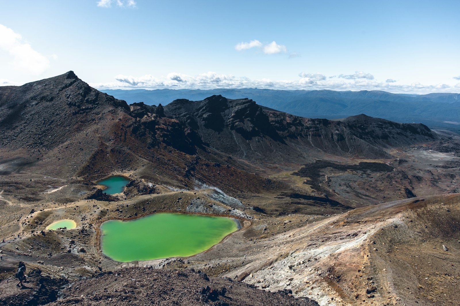
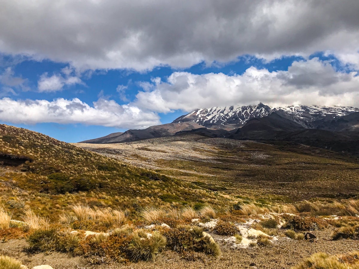
South of Taupō the road runs down the lake to Tūrangi, the gateway to Tongariro National Park — home to the famous Alpine Crossing, Mount Ruapehu and the towns of Ohakune and Whakapapa. Then comes the Desert Road: the high, bare crossing of the Rangipō plateau, with the volcanoes on one side and tussock to the horizon. It's a highlight — and the stretch to plan around (see below).
Waiouru → Wellington (~3 hours, ~255 km)
Off the plateau at Waiouru (fuel and the Army Museum), the road winds down through Taihape and the farmland of the Rangitīkei, out to Bulls, then south through the Horowhenua — Levin, Ōtaki, Paraparaumu — and along the Kāpiti Coast into Wellington. The capital sits around one of the country's great harbours, and it's the launch point for the ferry south.
The Desert Road: the stretch to respect
Where to stay: camps along the way
The middle of the route is the best place to break the drive:
- Taupō — a big lakeside town with plenty of holiday parks, roughly the halfway mark and full of things to do (the lake, Huka Falls, hot pools).
- Tongariro National Park — Tūrangi, Ohakune and Whakapapa Holiday Park put you close to the Alpine Crossing and Mount Ruapehu.
- Hamilton / Waitomo — handy first-night stops if you leave Auckland late in the day.
- Kaitoke Regional Park — campervan camping a short run north of Wellington, a good last night before the city or the ferry.
Carrying on to the South Island: the Cook Strait ferry
For many people this drive is the run down to the Cook Strait ferry. Wellington is the North Island terminal, with Interislander and Bluebridge sailing across to Picton in about 3 hours 20 minutes to 3 hours 30 minutes. You book by your vehicle's length and height, and you should arrive at the terminal 60 to 90 minutes before departure. Summer sailings fill up, so book a campervan or caravan well ahead. From Picton you're straight into the South Island — and routes like Christchurch to Queenstown.
Wind on this route
Two parts of this drive are notably windy in a tall rig: the Desert Road across the open plateau, and the lower North Island and Wellington, which are among the windiest places in the country. Because the forecast headline wind speed hides the gusts that actually move a high-sided vehicle, check a briefing that reports gusts before exposed legs, slow down in strong wind, and be ready for a shove when you pass a truck or come out from behind shelter.
Check the wind on the plateau → The free Touring Brain weather briefing flags gusts at cab height — not just the headline wind speed — so you can decide whether to drive the Desert Road, wait or reroute.Frequently asked questions
How long does it take to drive from Auckland to Wellington?
About eight hours of pure driving via SH1, but in a campervan, motorhome or with a caravan, plan closer to nine hours plus stops — the rig is slower and there's the plateau to climb. It's a big day in one go, so most people split it with a night around Taupō or Tongariro.
Can you do this drive with a caravan?
Yes — SH1 is a well-built highway suited to towing for nearly all of its length. The one stretch to plan around is the Desert Road: check the forecast and road status, watch for crosswinds, and use the signed detour if it's closed by snow.
What's the best time of year for this trip?
It's a year-round drive. Summer gives long days and warm weather; winter is quieter and often clear, but the Desert Road can get snow and ice, so check conditions and carry chains if heavy snow is about.
Sources & further reading: road conditions, the Desert Road and winter closures — NZTA Waka Kotahi Journey Planner; campsites and freedom-camping rules — Department of Conservation; the ferry — Interislander / Bluebridge; mountain weather and wind — MetService. Distances and times are approximate and were last reviewed on 19 June 2026.
This guide is general touring information, not legal or driver-training advice, and conditions change quickly. Always follow road signs, current speed limits and NZTA Waka Kotahi guidance, check road and weather conditions before the Desert Road and other exposed routes, confirm campsite and ferry availability before you rely on them, and drive to the conditions on the day. Touring Brain is independent and not affiliated with NZTA, DOC or any ferry or rental operator.
Photos: Tongariro Emerald Lakes — Tomáš Malík; Central Plateau — sara nudaveritas; Wellington — Sulthan Auliya (Unsplash).